
One year later than planned, I am finally spending some time In Barro Colorado Island (i. e. BCI) to conduct to do the research I planned to undertake at STRI. I just finished placing bags to differentially exclude pollinators and in a few days we should start understanding something about the evolution of weevil brood pollinators in generalist palms!
But this is not what I’d like to write about today. Instead, I’d like to share a tool that I have been using for a while and I think other people who spend a lot of time in trails could make use of it. This is OpenStreetMap, and I’m a fan.
Have you ever wished that you could use your GPS to navigate through trails as well as it does through streets? How to add trails that are not available in online maps?

Bagged flowers of the palm Oenocarpus mapora
This is a problem I encountered, for example, here in Barro Colorado. Even though the trails are well mapped, when I set my GPS to go to a specific point it attempts a straight line. This is bad for planning routes and for me to have a realistic idea of how much I have to walk, so ideally I would want it to route through trails. Below I explain how I put the trail information in a map in my GPS, and actually made it available to everyone in the process.
What is OpenStreetMap?
OpenStreetMap is akin to a Wikipedia of maps: anyone, anywhere in the world can edit, and through time it gets more and more accurate. This content is distributed freely under a Creative Commons license. This means that there is a whole community using OpenStreetMap data for all sorts of products, including maps that can be loaded in Garmin GPS units, the brand that I use.
How to load a map from OpenStreetMap to Garmin?
Since there is a large community of knowledgeable people working on optimizing maps for Garmin devices, all you need to do is to follow their advice. The ideal map depends on your intended usage (like driving, sailing or hiking) and region of the world. Check out this page for details.
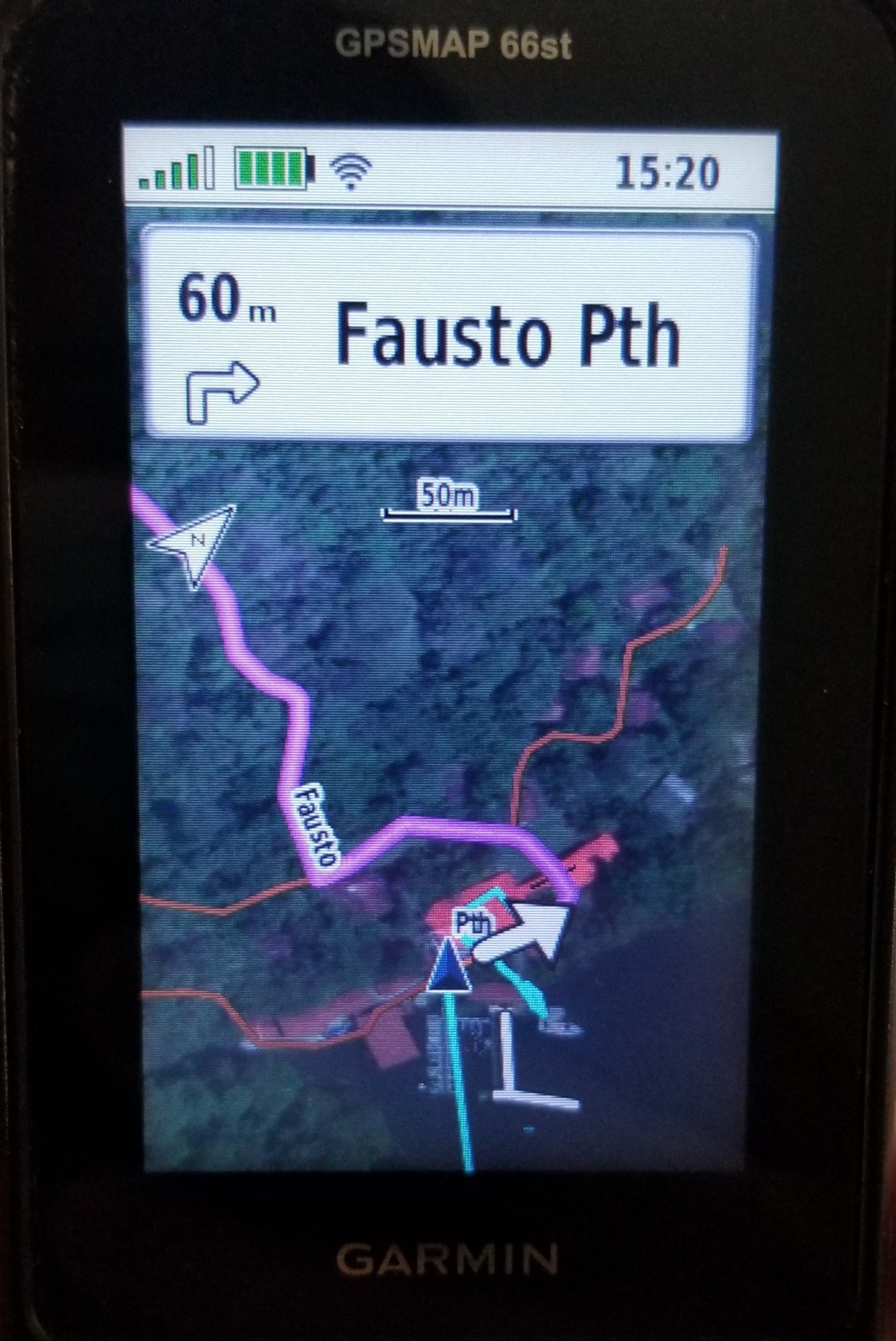
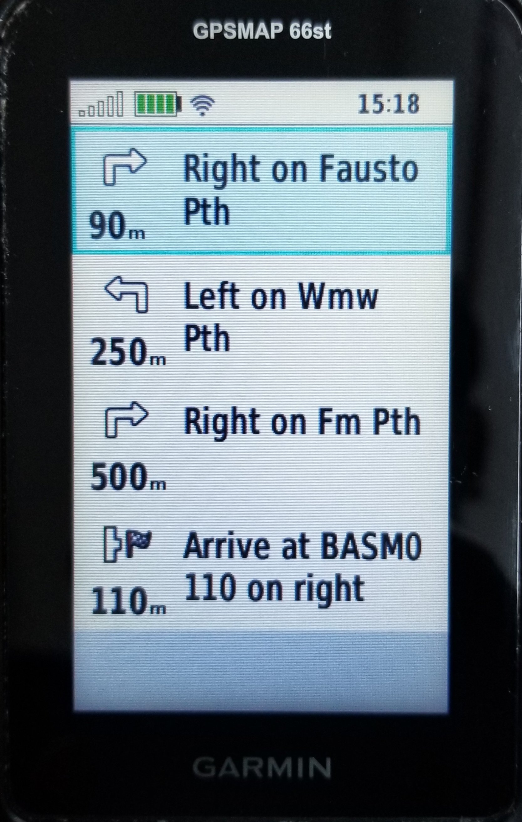
For the record, I am currently using a map of Central America optimized for hiking and mountain biking: https://openmtbmap.org. They update weekly, so all I have to do is to edit OpenStreetMap to make sure it includes the trails that I need. Then a week later I can download a nice map that works in my GPS device. I did this last week, and now my GPS shows the exact distance through trails and instructions on how to get to the palm trees in which I placed bags:
How to add trails to OpenStreetMap?
The very first page of OpenStreetMap there is a button named EDIT. There you can use satellite images or GPS tracks that have been uploaded to the website to trace trails manually. In my case, I did not need to do that since the Smithsonian Institution already provides maps for BCI trails. Fortunately, they are distributed under a Creative Commons license as well, so I could use that data as base to create trails in OpenStreetMap. Just like Wikipedia, my edits are tracked with an ID and there one can see where the information came from: https://www.openstreetmap.org/changeset/113428019
Since I already started with a file containing edited tracks and names for all trails, I did not manually edit them in the website. Instead, I used JOSM, a program to edit OpenStreetMap that runs in my computer. Consulting the documentation of JOSM, in about an hour I figured out how to transform the raw data from STRI into the kind of data that shows that these are connected hiking trails. The program did a few automated checks and fixes to make sure everything looks right before uploading, and done.
Then I only had to wait a few days until someone used those new additions to OpenStreetMap to create a map suitable for my Garmin device, and follow their installation instructions.
This all seems hard, is there another way to help?
Yes! If while working in the field you have your GPS on all the time, like I do, it will generate traces (or tracks). Those are files that show where you have been, for example, throughout one day. You can download those traces from you gps (for example, using Garmin Explore or Garmin Basecamp) and upload them to OpenStreetMap. Other users can then use the traces to manually refine maps. For example, here I show a trace from one day I was in the field last week, and we can see that the BCI trail map does not match it exactly. If we had a number of these traces from many users (to account for GPS errors), someone could improve this map manually.

OpenStreetMap edit window showing mapped BCI trails (yellow) and GPS tracks from one day of my fieldwork (pink)